Understanding the Village Conservation Overlay District in Lucketts
2/24/2026
Lucketts is designated as a Rural Historic Village in Loudoun County’s 2019 General Plan. That designation is implemented through the Village Conservation Overlay District (VCOD) in the Zoning Ordinance.
The VCOD is often referenced in discussions about growth, development, and village boundaries. But what does it actually do?
This article breaks down how the overlay works — and what it means for Lucketts.
Where the Overlay Applies in Lucketts
The Village Conservation Overlay District is mapped as a defined boundary around the historic core of Lucketts.
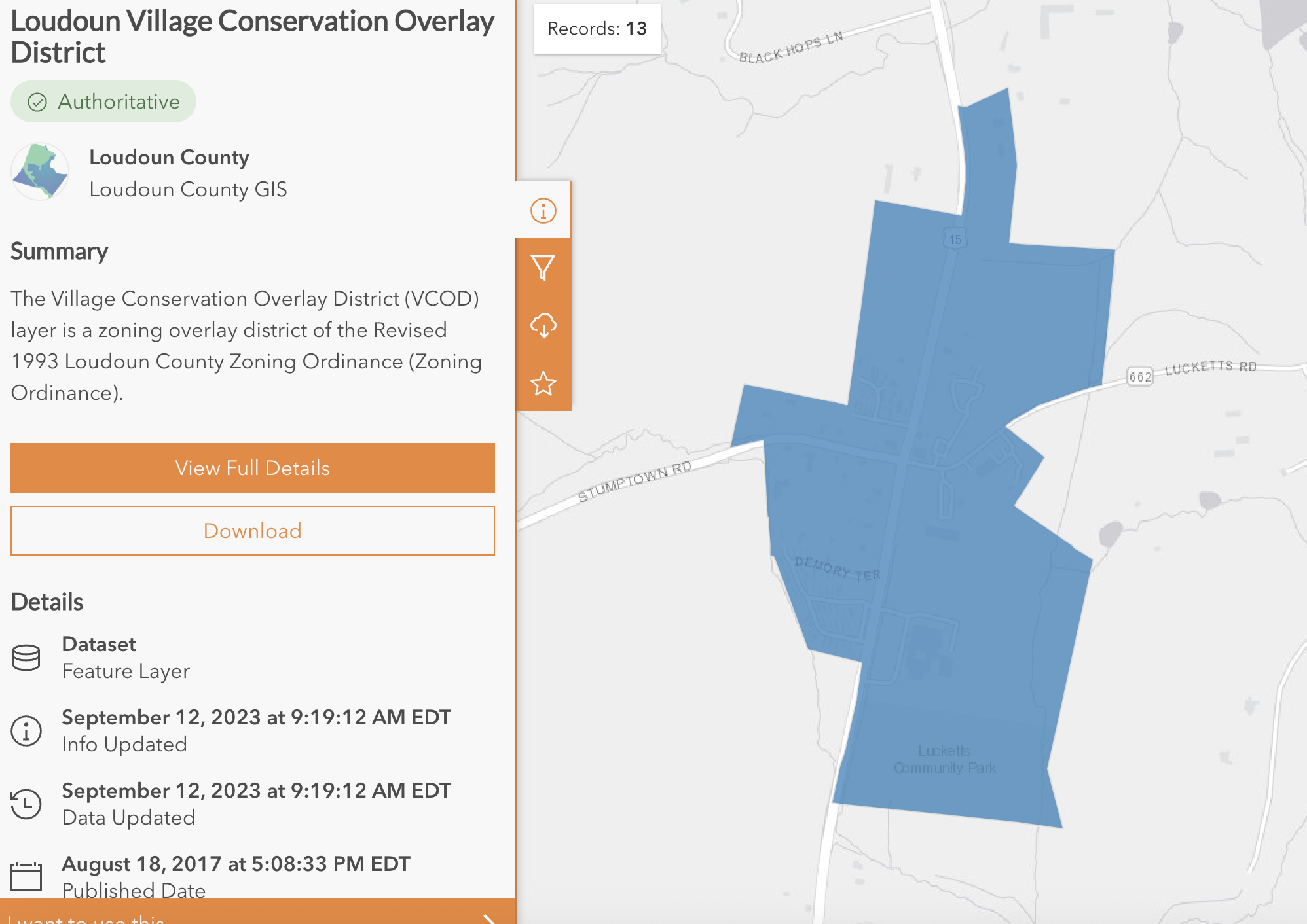
Map: Loudoun County GIS – Village Conservation Overlay District boundary in Lucketts.
Only parcels within that boundary are subject to the additional VCOD development standards.
The boundary defines:
- Where contextual compatibility rules apply
- Where village form must be preserved
- Where compact historic pattern is protected
- Where the rural “hard edge” begins
Changes to this boundary are Comprehensive Plan–level decisions.
How the Overlay Sits on Top of Base Zoning
The VCOD does not replace underlying zoning. It overlays it.
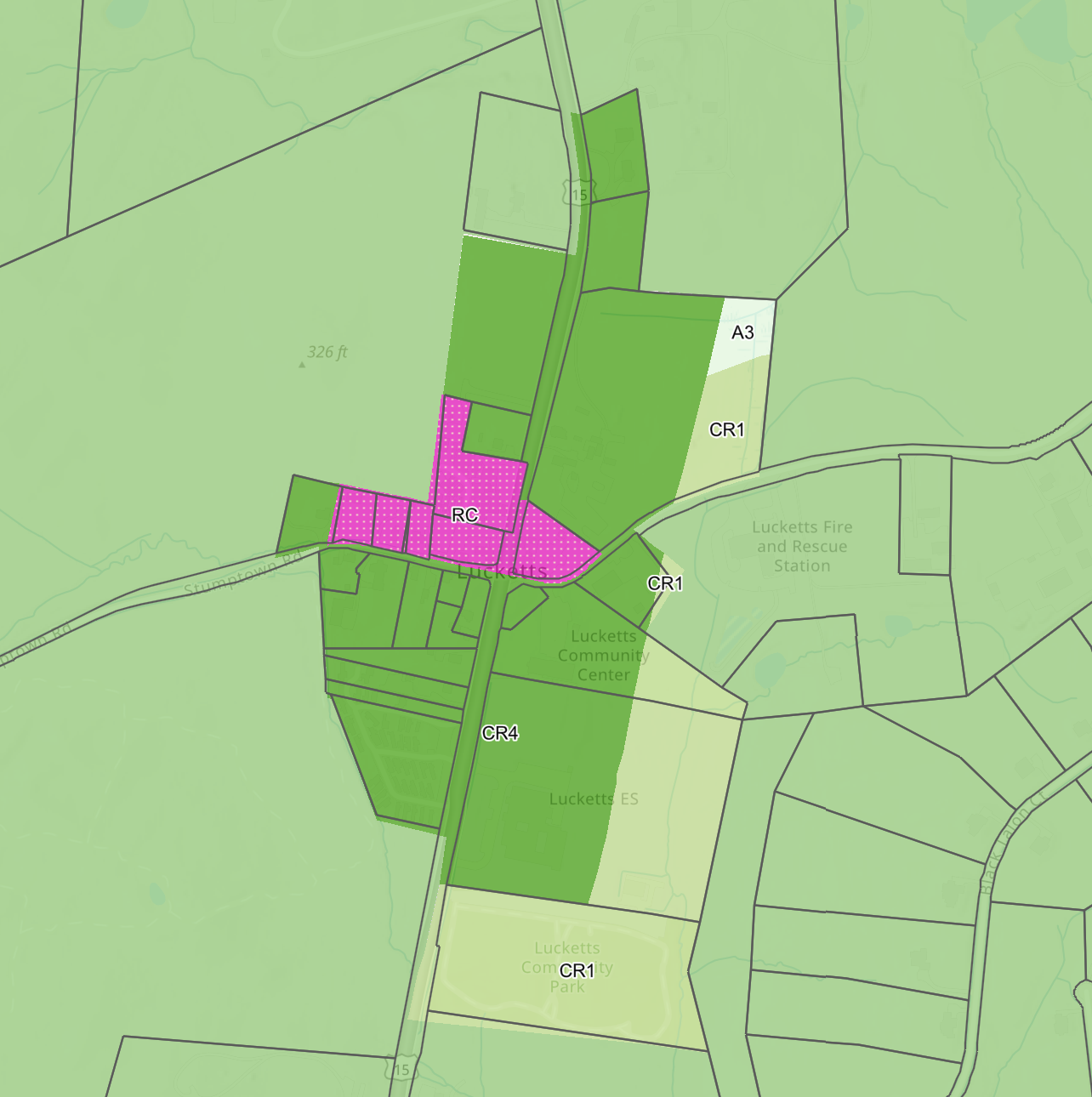
Map: Underlying zoning districts in and around the Lucketts village core.
Within and around the village core you’ll see:
- RC (Rural Commercial) in the historic core
- CR1 / CR4 residential districts
- Agricultural zoning surrounding the village
The overlay sits on top of these zones.
That means:
- Uses and density come from base zoning.
- Building form, scale, setbacks, and compatibility are governed by the VCOD.
The overlay controls how development fits, not simply how much is allowed.
What the Village Conservation Overlay District Is Designed to Do
According to the Zoning Ordinance, the VCOD is intended to:
- Implement the Rural Historic Village Place Type
- Preserve historic development patterns and spatial organization
- Protect compact, pedestrian-scale rural communities
- Maintain open space at village edges
- Ensure new construction complements surrounding properties
Lucketts is explicitly listed as one of the villages subject to the overlay.
How the General Plan Defines Lucketts
The 2019 General Plan describes Rural Historic Villages as:
- Small, compact communities
- Pedestrian-scale in form
- Low-density residential on smaller lots
- Limited commercial uses serving local needs
- Generally two stories in height
- Surrounded by preserved agricultural landscape
The Plan is explicit that:
- Conventional suburban forms are not appropriate
- Growth must reinforce historic development pattern
- Villages should maintain a defined “hard edge” separating them from farmland
This framework drives the overlay standards.
What the Overlay Actually Regulates
The VCOD is primarily about contextual compatibility.
1. Building Height
New buildings may not exceed:
- 25% above the average height of nearby buildings (within 150 feet)
- And may not exceed the underlying zoning maximum
This prevents abrupt vertical scale changes.
2. Building Size
New buildings must be within 50% of the average square footage of nearby principal buildings.
This prevents out-of-scale construction.
3. Setbacks
Front, side, and rear setbacks are tied to averages of nearby structures.
This preserves shallow village setbacks rather than suburban front-yard patterns.
4. Lot Patterns and Subdivisions
- New lots may not exceed the largest existing lot within 100 feet on the same road
- Subdivisions of 6+ lots must vary lot sizes
- Uniform suburban subdivision layouts are discouraged
5. Garages and Streetscape
- Detached garages
- Recessed front-loaded garages
- Two-car width maximum
This protects the pedestrian-scale streetscape.
The “Hard Edge” Concept
Both the Zoning Ordinance and the General Plan emphasize:
- Maintaining open space and natural areas at the perimeter
- Preserving visual separation between village and farmland
Lucketts is intended to remain:
A compact historic node within a rural landscape — not the beginning of outward suburban expansion.
Does the Overlay Increase Density?
No.
The VCOD does not increase density by itself.
- AR-1 remains AR-1
- RC remains RC
- CR districts remain CR
The overlay controls design compatibility — not density.
Any increase in residential density requires legislative approval consistent with the General Plan.
Why This Matters
Understanding the overlay clarifies several ongoing debates:
- What “village growth” actually means
- Whether proposals fit historic context
- How boundaries affect long-term character
- Where suburban form becomes inconsistent with adopted policy
The Village Conservation Overlay District is not a growth mechanism.
It is a form-control framework designed to preserve the historic scale, pattern, and identity of Lucketts while allowing limited, compatible evolution.